Airspace Software Solutions
MAST
SlopeVIEW
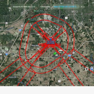
- Utilizes aeronautical data sourced directly from the FAA’s National Airspace System Resources (NASR) 28 Day Subscription, ensuring up-to-date and authoritative information.
- Automatically generates 14 CFR Part 77 surfaces for each evaluation, supporting regulatory compliance and accurate analysis.
- System functionality has been verified throu
- Utilizes aeronautical data sourced directly from the FAA’s National Airspace System Resources (NASR) 28 Day Subscription, ensuring up-to-date and authoritative information.
- Automatically generates 14 CFR Part 77 surfaces for each evaluation, supporting regulatory compliance and accurate analysis.
- System functionality has been verified through comprehensive manual testing, ensuring reliability and accuracy.
- Capable of analyzing a single obstacle or processing large-scale projects with over 30,000 obstacles in one evaluation.
- Supports the creation of airport KML files specifically tailored for 14 CFR Part 77, streamlining integration with geospatial tools and enhancing visualization.
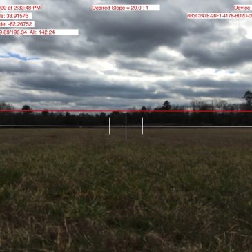
SlopeVIEW
SlopeVIEW
Quickly evaluates Approach and Departure surfaces to identify potential airspace surface penetrations, enabling users to determine when further detailed analysis is required.
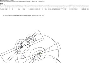
Airport Surface Evaluation
Airport Surface Evaluation
Provides an online evaluation tool for 14 CFR Part 77 and Visual Glide Slope Indicator (VGSI) analysis, capable of processing one or multiple objects simultaneously.